M I N E R A L O G I Q U E
  • Home
  • About
  • Services
  • Projects
  • Gallery
  • Contact
  • Blog

Landform and regolith in the Tenkoto area (Eastern Senegal)

12/29/2020

0 Commentaires


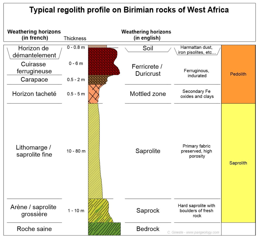
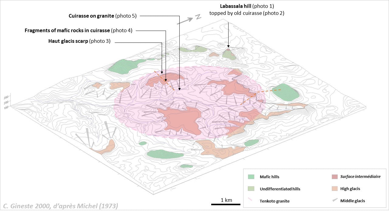
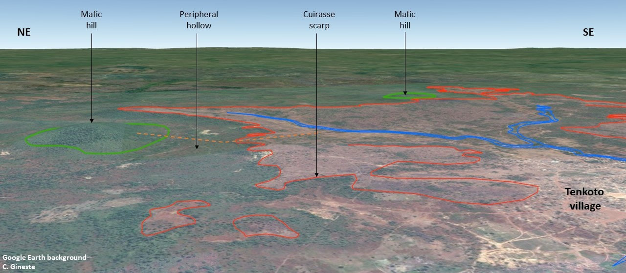
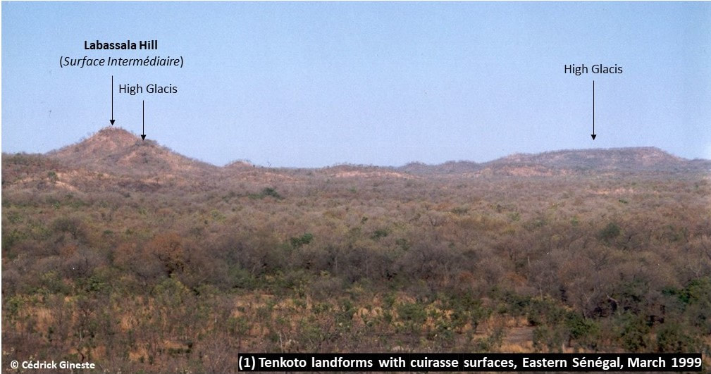
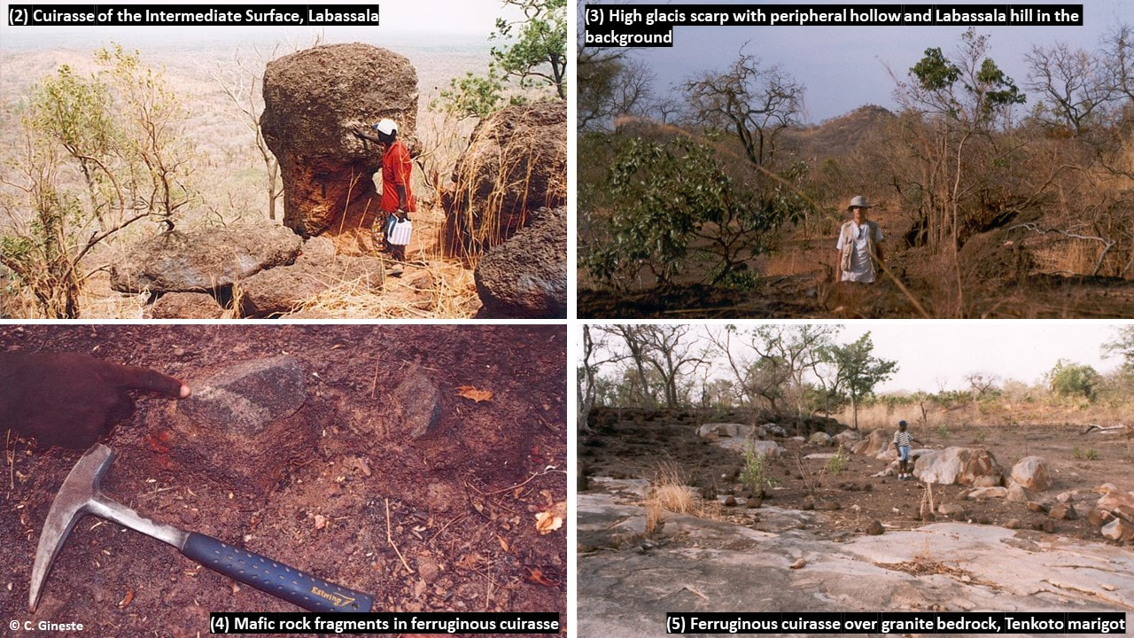
The weathering profile developed on the Birimian rocks of West Africa is, or looks, relatively simple. But its genesis is not. A few years ago, within a research team of IRD, I worked in the Tenkoto area (Senegal), already studied by P. Michel in the 60's and 70's and very adapted to examine the filiation of the ferricrete.

Pdf in English

tenkoto-2020_12_en.pdf
File Size: 1183 kb
File Type: pdf
Télécharger le fichier

Pdf en Français

tenkoto-2020_12_fr.pdf
File Size: 1193 kb
File Type: pdf
Télécharger le fichier

Photo


In the 1960s and 1970s, several BRGM and ORSTOM researchers were interested by the weathering profiles capped with a ferruginous duricrust (aka ferricrete or cuirasse in French), particularly in Senegal. Two schools of thought confronted each other on how the weathering profile was formed.
 
The autochtonist school (residual ferricrete)    
Nahon, Pion and Leprun studied the weathering processes on a geochemical scale and see the profile as a logical succession of alteration that gradually deepens. They consider ferricrete as the ultimate stage of rock weathering.

The allochtonist school (transported ferricrete)
To these three authors, who envisage the autochthony of ferricrete, is opposed the vision of the geomorphologists Michel, Grandin, and Boulet, who studied ferricretes on a much larger spatial and temporal scale. Indeed, they distinguish the residual bauxitic duricrust of the old African Surface from the younger ferricretes which, according to them, largely correspond to the cementing of detrital material and the remobilisation of iron from the overlying duricrusts in the landform.

To put everyone in agreement, it would seem from our experience that both cases of residual or transported ferricrete can be found in West Africa - even if they are mostly transported.

Let's look at a typical case of a transported ferricrete following the footsteps of P. Michel who studied the geomorphology of Eastern Senegal and particularly the Tenkoto area (where I worked in 1999-2000).

Photo


The study area is centred on the Tenkoto granite batholith. It is a Bondoukou (post-tectonic) granite in the Bassot (1966) classification. It has a circular shape with a diameter of 5 km and intersects the terranes of the Mako series. It is visible on the outcrop mainly in the talweg that crosses it from NE to SW.

Quartz veins mineralised in Pb, Zn, Mo and Au occur at the edge of the granite and are the target of orpailleurs. The Massawa gold deposit, discovered by Randgold a few years ago, is located about 5 km NE of this area.

A set of hills that have resisted erosion form a discontinuous belt around the Tenkoto granite. The most remarkable relief is the hill of Labassala located to the N-W of Tenkoto at an altitude of about 280m. It has a conical shape with regular flanks, its summit is topped by a relic of duricrust from the Intermediate Surface, believed to be of Pliocene age, which limited the erosion of the underlying schists. The other hills, made up of basic rocks, have a classic rounded shape of inselberg type.

Photo
Photo

​Granite is largely hidden by two stepped ferricrete surfaces (or pediments/glacis), organised in relation to the NE-SW oriented marigot of Tenkoto and its tributaries, the high glacis being about ten metres above the middle glacis. The ferricrete plateaus are bordered by trees fringes at the level where they break up on the wooded slopes leading to the lower level.
The glacis are separated from the basic rocks’ hills by a deep peripheral hollow where the rock, or saprolite, is subcropping. This results in a landscape of inverted relief, which is particularly clear to the north-east of the area. 

Photo
Photo

 
The texture of the ferricrete clearly shows that it is allochthonous, with locally distinctive basic rock fragments in the ferruginous material capping the weathering profile on granite. In the lower part of the middle glacis, the ferricrete rests directly on the granitic bedrock.
 
Michel's interpretation distinguishes three phases of erosion separated by two periods of ferricrete formation. Wet periods favoured weathering at depth and the formation of ferricretes while the resulting landscape was eroded and dissected during dry periods, leading to new landforms and the current shape of stepped high glacis and middle glacis.

Photo

  
In such a context it is easy to understand that not all soil geochemical gold anomalies (positive or negative) are alike. A mapping of the landforms and the regolith is therefore necessary. New technologies such as Lidar and satellite imagery are now available to facilitate this work, but a field mapping with landscape reading will always be necessary to decipher the geochemical results. We will come back to this later.
 
Few references

Michel P. (1973) - Les bassins du fleuve Sénégal et du fleuve Gambie. Etude géomorphologique. Mémoire ORSTOM n°63, 752 p.
​

Beauvais A. et al. (1999) - Analysis of poorly stratified lateritic terrains overlying a granitic bedrock in West Africa, using 2-D electrical resistivity tomography. Earth and Planetary Science Letters 173, pp. 413-424.
​

0 Commentaires

Weathering profile on carbonate rocks of the Nyanga syncline, Gabon

12/10/2020

0 Commentaires


Even without remarkable minerals, I find regolith fascinating. Given the questions raised by my last post, I suggest staying in Gabon and see what the weathering profile looks like a few kilometres away from the Ikoundou Mountains and their hyaline quartz.

Let’s head for the plain of Tchibanga which is characterized by a beautiful savannah clearly visible on satellite imagery. It constitutes the south-western flank of the Nyanga syncline, the heart of it being the Schisto-Greseux group while the flanks are made up of the Schisto-Calcaire group. A particularly good example of the geological control of vegetation.

The carbonate units have been weathered much more easily than the metamorphic and igneous units surrounding them (Mayombe in the South and Chaillu in the North). The result is a karstic relief with rare pinnacles of limestone rock emerging from the savannah.

The Stone Line is much thicker and consists of large cuirasse blocks, some of them metric in size. While it works rather well on the surrounding relief, unsurprisingly, surface geochemical exploration is not applicable in this context.

0 Commentaires

Another Mineral Story 8 - Quartz crystals in the Gabonese Stone Line

12/2/2020

1 Commentaire


Gabon is a country with an equatorial climate and a thick, omnipresent vegetation cover. In this challenging context outcrops are extremely rare and road works are a blessing for the geologist in search of lithological and structural information.

A few years ago, road works between Ndende and Tchibanga uncovered beautiful sections of Gabon's distinctive weathering profile. We used the opportunity to sample the saprolite in order to obtain valuable geochemical information.

In the Ikoundou Mountains, located in the heart of the Nyanga Syncline, quartz veins are found in Neoproterozoic sandstones. Several large free crystals were encountered almost intact in the Stone Line, proof that this horizon is transported over only a short distance.

1 Commentaire

A la recherche du gypse numérique d’Occitanie Repères pour utilisation et validation des données géologiques dans un monde numérique

11/22/2020

0 Commentaires


Sorry for my english readers, but this one is only in French at this stage.
​
Voici un cas d’école sur les travers d’une certaine cartographie géologique moderne, parfois déconnectée du terrain et qu’il m’a semblé intéressant de documenter.
 
Il ne s’agit pas de pointer les erreurs ou les responsabilités de tel ou tel, mais plutôt de faire prendre conscience qu’encore en 2020 (et surtout en 2020, à l’heure du Big Data), ces données numériques ne sont pas la panacée.

gypse_numerique_de_marcillac.pdf
File Size: 1467 kb
File Type: pdf
Télécharger le fichier

Photo
0 Commentaires

Another Mineral Story 7 – Phosphates from La Capelle Bleys

6/10/2020

0 Commentaires


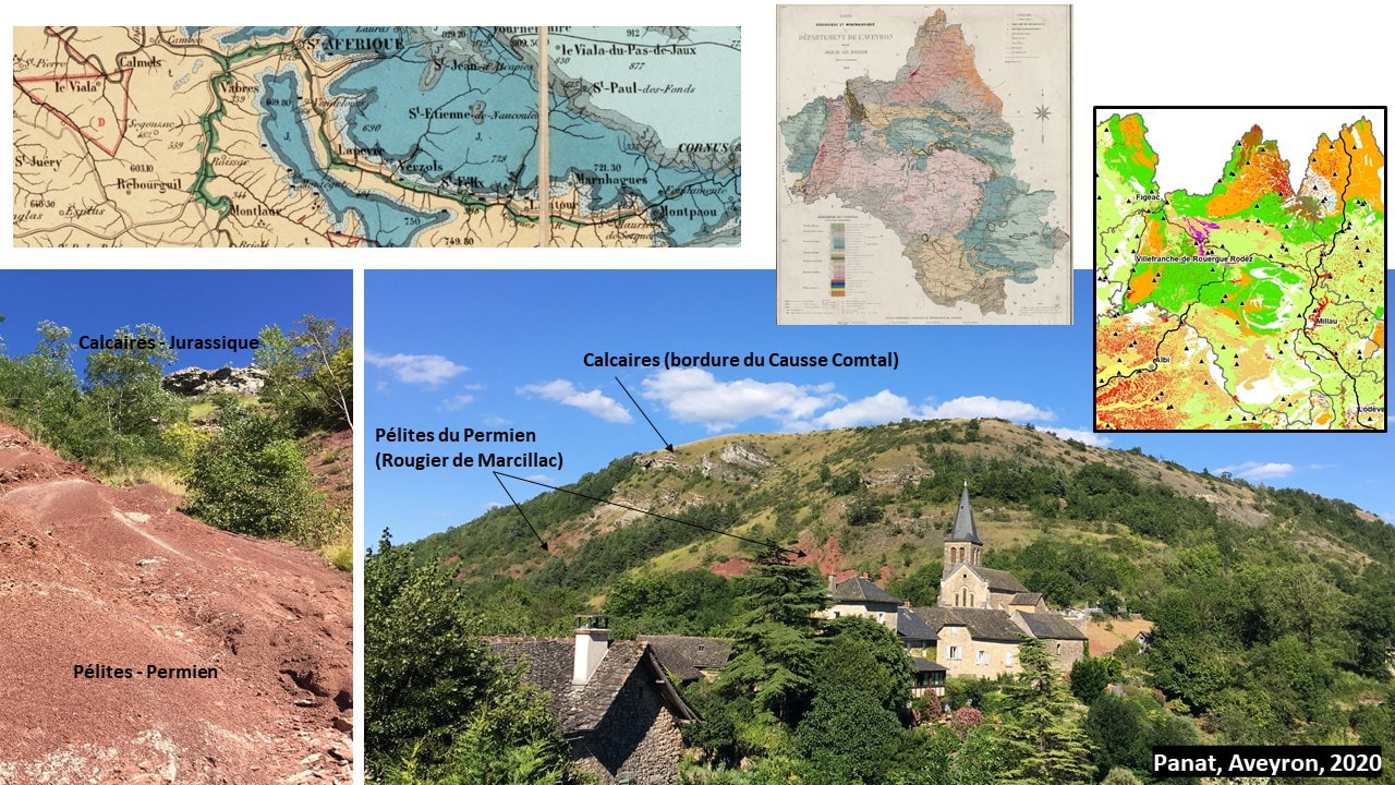
With the recent easing of the lockdown in France, and before being able to return in the field overseas, three days ago I did a small field trip in my native geological backyard, around Villefranche-de-Rouergue, in Aveyron.

The Villefranche granitic massif and its periphery are rich in quartz veins with Pb-Zn-(Cu) mineralization, particularly along the famous Villefranche fault that separates the Variscan basement from the Aquitaine basin. La Capelle Bleys (LCB) leucogranite massif which stands out to the east, is located in a favorable position at the intersection of several major faults, including the Sillon Houiller, giving more diverse mineralization. This small zone was explored for uranium, tungsten, and fluorite in the 1970s the early 80s.

About 10 years ago with a group of prospector friends, we found there and described a suite of rare mineral species. Fractures and thin oxidized quartz-pyrite veins are filled not only by secondary uranium phosphates but also by species such as natrodufrénite, leucophosphite, meurigite, cyrilovite and kapundaite. This time I was lucky enough to find nice autunite and maybe libethenite, a new phosphate for the site to be confirmed by analysis.

0 Commentaires

Another Mineral Story 5 -  Cobalt minerals in the regolith profile of New Caledonia

6/3/2020

0 Commentaires


In the early 2000s, during an exploration drilling program on the rim of the Goro deposit, our earthworks uncovered an old adit. It was dug by ‘cobaleurs’, those cobalt miners who were active in New Caledonia at the beginning of the 20th century. At that time, the Caillou was almost the only world producer of this rare ore, then the discovery of the Copper Belt and its rich sulfides and oxides Co deposits will rapidly reduce New Caledonian production.

The Co bearing phases are composed of minerals such as heterogenite and asbolane. These manganese-cobalt-(nickel) hydroxides are mainly found in the oxide ore (yellow laterite), just above the contact with silicate ore (saprolite). Their indurated forms were the target of the cobaleurs. They form encrustations along root systems that are particularly common when the oxide ore is close to the surface and would suggest that deposition of these minerals occurs particularly at the level of fluctuating water table.
​
Today, New Caledonia is a small producer, with cobalt being a by-product that is used to valorize its low-grade nickel ore processed on site at the Goro HPAL plant or exported. This ore is supposed to be 'clean ore' compared the one coming from some operations in the DRC.

0 Commentaires

Another Mineral Story 5 - Gillardite from Widgiemooltha

5/27/2020

0 Commentaires


In 2005, during a nickel exploration program in the vicinity of Kalgoorlie, I found the opportunity to visit the 132 North nickel mine. The small deposit located near Widgiemooltha, away from the famous Kambalda dome, is modest in terms of resources, but special from a mineralogical point of view.

Classically in a nickel deposit the secondary species are not varied and limited in number; arsenates such as Annabergite in sulphide-type deposits and silicates such as Népouite in laterite-type deposits.

Ernest H Nickel who studied the mineralogy of the mine exploited by WMC in the 90s identified more than fifteen secondary nickel species. This makes 132 N the most prolific deposit in mineral species for this metal.
​
In the supergene profile, the primary sulfides pyrrhotite-pentlandite-chalcopyrite are altered to violarite-pyrite, and then to nickel carbonates, topped by an Fe-oxides and silica gossan layer. Veins are filled by carbonates (Gaspéite, and rare Kambaldaite, Widgiemoolthaite), but also sulfates (like Hydrohonessite), silicates (Népouite) and chlorides. Few years ago, what was labeled Paratacamite has been identified as a new species, Gillardite - nothing to do with the former PM.

0 Commentaires

Another Mineral Story 4 - Cornetite from the Blue Mine, South Africa

5/20/2020

0 Commentaires


During a field trip in South Africa, I visited the famous Blue Mine in Springbok. This old mine is part of the O’Okiep copper district located in the Namaqualand Metamorphic Complex.
​
The Blue Mine is historically significant as it is considered as the first ‘mining operation’ in South Africa. The mineralised outcrops have been mined by the indigenous people of Namaqualand long before the arrival of European, but industrial mining started only in 1852 with this very mine.

Copper mineralisation is found in isolated bodies of mafic intrusive rocks like orthopyroxenite. This magmatic sulfide deposits are still difficult to classify with high Cu/Ni and Cu/S ratios and possible similarities with IOCG deposits. Economic sulfides are mainly chalcopyrite and relatively abundant bornite. On many deposits metamorphic and meteoric fluids have remobilized Cu to form sulfides such as chalcocite and covellite.

The Blue Mine name founds its origin in the secondary minerals formed in the oxidation zone. But not much carbonates such as azurite in this context, instead supergene species are mainly phosphates like cornetite and libethenite, with also silicates (chrysocolla).

0 Commentaires
<<Page précédente

    Author - C. Gineste

    Field notes, photos and memories of outstanding outcrops and rocks observed during my geological wanderings.

    Archives

    Décembre 2020
    Novembre 2020
    Juin 2020
    Mai 2020
    Avril 2020
    Mai 2017

    Catégories

    Tous

    Flux RSS

Proudly powered by Weebly
  • Home
  • About
  • Services
  • Projects
  • Gallery
  • Contact
  • Blog